Want to adopt this trail? Become an Ambassador!
Air Line State Park Trail - South
The Air Line State Park Trail is an abandoned railroad line that runs through rural central Connecticut.
Loop Trail? No
Type: Greenway, Rail Trail
Agency: State
Entry Fee? No
Parking Fee? No Allowed Uses:
Bicycling (on pavement)
Dogs - On leash
Pedestrian - Walking/Hiking/Running
Snow - Cross-country Skiing
Join a cadre of volunteers to help improve the data on this trail.
Location: East Hampton, Colchester, Hebron, Lebanon
State(s): Connecticut
Counties: New London, Tolland, Middlesex
Longitude: -72.50219
Latitude: 41.57513
Driving Directions
East Hampton: Cranberry Meadow on Smith Street; A large Air Line Railroad sign highlights the the trailhead. (Handicapped accessible)
Colchester: Bull Hill Rd (Handicapped accessible). River Rd; To reach the trail, take the path through the woods south of the parking area. Or, take a detour along the unpaved portion of River Rd following Salmon River to Bull Hill Rd and access the trail a short distance north (Handicapped accessible and will accommodate horse trailers)
Hebron: Rte 85; A large parking area next to "Rte. 85 Lumber." (Handicapped accessible and will accommodate horse trailers) Old Colchester Rd; limited parking. Grayville Falls Park; Go east from the parking lot, cross the open meadow and then the bridge over Raymond Brook, and climb the embankment to the trail ((Will accommodate horse trailers). Grayville Rd; Handicapped accessible where the Air Line Trail intersects Grayville Rd. Old Hartford Rd; limited parking.
Description
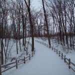
The Air Line State Park Trail is an abandoned railroad line that runs through rural central Connecticut. Approximately eleven miles have been resurfaced with stone dust and bridges; parking lots are near completion. Another ten miles are scheduled to be completed and are presently under construction.
The trail passes through forests, rock-cuts, meadows and borders wetlands and marsh areas. Several rivers and streams are crossed with two viaducts that provide wonderful views of the area.
Photo by Stan Malcolm
Additional Details
Width: 96 inches.
Primary Surface: Crushed Rock
Secondary Surface: Crushed Rock
Average Grade: 5%
Maximum Grade: 5%
Elevation Low Point: 260
Elevation High Point: 480
Elevation Gain (cumulative): Not Available
Year Designated:
Supporting Webpages and Documents
Website: Along the Air Line, photos by Stan MalcolmWebsite: State of Connecticut webpage for the Air Line Trail
Contact Information
For more information and current conditions, contact the trail manager (listed below). For questions, suggestions, and corrections to information listed on the website, contact American Trails.
David Buckley
Connecticut State Parks
209 Hebron Rd.
Marlborough, CT
6447
(860) 424-4173
david.buckley@po.state.ct.us
Photos
Reviews
Suggest an Edit
Do you see a problem with this trail data? Contact us below: